Weckworth's Adventures

This Blog will be a way for us to share our travels with family and friends. We may not be too regular with our posts but will try to keep them up. To see where we are at any time click on the link below.

Sunday, July 30, 2006

More Chimney Rock Adventure


From the lower area we began to climb up along an old trail towards the upper site on Chimney Rock. The climb is strenuous as it is 7,400 feet in altitude! You had to watch you footing all the way up to the top.


H
Here is a picture of the Navajo from Taos Pueblo explaining in great detail his interpretation of what we are seeing. This added a great deal to the visit.


This is a look at the Kiva at the top of the ridge. There are a number of rooms surounding the kiva and no one really knows what they are for as the archaeologists did not find any debris from any inhabitation of these rooms.

The masonery of these places is just fabulous. The built all of thier walls of a outer layer of finely laid rock on both sides and an inner layer of fill rock between them. To look at their workmanship and to remember that they only had stone tools, you begin to appreciate their skill. Then to finish it off they plastered over the fine stone work! All of the plaster has weatherd away leaving just the stones.


Here we finally arrived at the pinnacle and have a view of Chimney Rock and Companion Rock!
The view from up there was just magnificent. The guide pointed out a ridge to the south about 90 miles and said that it was Chaco Canyon.

This visit was educational in many ways. We really enjoyed the time and effort we spent in order to see it all. Posted by Picasa

1 Comments:

Blogger Unknown said...

This is another one of your cool excurtions. Thanks for sharing the experience. That climb looks like a bummer, but a cool reward to see the kiva when you get there. How fortunate to have a navajo from Taos to give you his interpretation too.

You two are leaving few stones unturned on your sweep through the mountains this summer. You sound like you've enjoyed it all, except the bathrooms at the one state park!!!!

I'm loving the education I'm getting!

10:32 AM  

Post a Comment

<< Home

Chimney Rock Archaeological Area

While in Pagosa Springs we decided to visit this site of ancient Indian ruins. You meet the guide at the bottom of the mountain and then follow the guide up to the upper area in your car. Once you get to the parking area you begin a wonderful tour. The site is considered an outlier of the Chacoan Culture. Chaco Canyon is about 90 miles due south and the stonework and layout are similar.

No one really knows why the ancient indians would build up so high as this site so everything is speculation.

This is known as the "Great Kiva". It was a meeting place and while most kivas had a roof over them made of logs and adobe and they entered it through a hole in the roof this one seems to not have had one. Some think it was for religious ceremonies that they gathered in these Kivas but we had a Navajo visitor from Taos Pueblo with us and he said that kivas were and are used for all types of gatherings.


Here Barbara tries out the indian way of grinding corn. She decided that it was better to use an electric grinder! Most of the ancient Indians would end up without any teeth left after the age of 35 or so because of the residual stone particles in their corn meal from this type of grinding.


This perfectly round hold in a solid rock baffles the archaeologists. It is only about 4 inchs deep and there are no other items close to it.

If you stand behind it and look towards Chimney Rock you are in a perfect location to observe the solar and lunar activity.

I will post another post about this visit as the system only allows a few photos per post. Posted by Picasa

1 Comments:

Blogger Jeri said...

The scenery in this area looks beautiful. I love that waterfall. Thanks for the all the pictures and the history lessons.

These ruins look very interesting. Ancient civilizations of all kinds facinate me. They did so much with so little and were quite ingenious problem solvers. I love the fact that with all of our infinite wisdom, we still can't figure out all of their secrets. It just amazes me.

Thanks again for taking us along.

8:44 AM  

Post a Comment

<< Home

Saturday, July 29, 2006

Treasure Falls

On the west side of Wolf Creek Pass there is a waterfall that is known as Treasure Falls. We had to make a trip back to see them as we did not want to stop the coach on the way past. The falls are quite senic.

This photo is how it looks from the roadside stop.


This is what it looks like through the telephoto lens on the camera. We decided that we were too old and too out of shape to walk all the way up to the falls for a closer look.


This sign was next to the Treasure Falls sign and now I know why the falls have the name! If you click on it and expand it you can read it. Posted by Picasa

1 Comments:

Blogger Unknown said...

OOOOH Wee! Hidden gold! Now that would be something to stumble on to. Imagine, stowed away somewhere for 300 years? Gold is still gold though in 2006! That's a nice waterfall. Yep a telephoto lens is the way to get a closer look when we get older!!!! LOL!

8:58 AM  

Post a Comment

<< Home

Friday, July 28, 2006

Interesting Neighbors in Gunnison

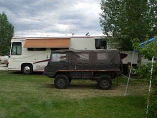
The day we left Gunnison we found an influx of military type vehicles to the campground.
These 4 wheel drive units are from Sweden and are sold to the US after their use in the Swedish army. They are of mid 1970's vintage and are lovingly rebuilt by their new owners. There is a large group from Colorado that uses them to go out on 4 wheel drives through the back roads of the mountains.


This will give you an idea of the size of these vehicles. That is our coach in the background. The name on the front of the truck is Pinzgaur by Styer. They seem to be very well made and rugged which I suspect is their attraction to those wanting a unit to go anywhere in the mountains.


Not sure what a Treffen is but that is their sign at the gathering place. Posted by Picasa

1 Comments:

Blogger Unknown said...

That picture with the military vehicle next to your coach is cute. They aren't very big, but I bet they get around rugged areas. For every interest their is a group to join, isn't there?

1:08 PM  

Post a Comment

<< Home

Wednesday, July 26, 2006

More Gunnison Pioneer Museum

The museum is in a campus type setting with a number of buildings holding displays of pioneer artifacts and some buildings from pioneer times.

In the railroad depot we found this wonderful trunk complete with its interior compartment boxes. They are very elaborately covered with drawings and scrolling. I have seen many trunks but never with the original interior.
This typewritten page was found on the teachers desk in one of the school houses on the campus. It is full of advice on how to conduct yourself as a teacher and how to save money for your old age. If you click on it and make it larger maybe you can read it as well.


In the first building we went through there was a large display of arrowheads found around the southwest. This display held 1,500 specimens. There were a couple of other displays of arrowheads and it was quite impressive.


This school house was unique and interesting to us. It was built 1910 for a cost of $1,900.00. The man who built it had a background in shipping and he fashioned the room on the front right into a round almost lighthouse looking room. The windows were curved to fit the shape of the room!

There was way too much to list here and we would recommend a visit to see it all.

2 Comments:

Blogger Unknown said...

This place sounds like you could spend some time there looking at everything. That school is quite unusual. Thanks for the photos of this place.

1:15 PM  
Blogger Jeri said...

Unique architecture for a school house!

8:25 AM  

Post a Comment

<< Home

Gunnison Pioneer Musuem


We found a car that is just like the one that Barbara had when we got married. The only difference is that hers was pink on the bottom instead of the green! It is a 1960 Nash Rambler 4 door. When Barbara and her family took it to Colorado they utilized the feature where the front seats would lay down and you could fill in the gap between the front and back seats which for them made a nice place for them to hold a card game while another person did the driving. We later used this feature when we attended the drive in movies. We could put the front seat backs down and sit with our backs on the rear seat and our feet comfortably stretched out as if we were in a recliner! Now don't go reading too much into this!!!

They had a lot of cars on display from early 1900's on up. Real nice building full of nostalgia.

1 Comments:

Blogger Unknown said...

Yep! I remember that Nash Rambler! I didn't know about those seats though! I believe ya!!! That's fun to run on to those blasts from the past!

1:12 PM  

Post a Comment

<< Home

Monday, July 24, 2006

Blue Mesa Reservoir

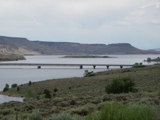
Blue Mesa Reservoir to the west of Gunnison, CO is the result of a dam on the Gunnison River. The lake runs for 23 miles and is a very popular fishing lake.
Barbara's mother and father used to come out here for a number of years to fish and get away from the hot weather in Kansas. Later they were joined by her uncle and aunt who lived in Loveland, CO. They had a boat and spent many happy hours on this lake. Posted by Picasa

0 Comments:

Post a Comment

<< Home

Black Canyon of the Gunnison

As we continued on from the area of the previous post along the northern side of the Gunnison River we arrived at our planned destination for the day, the Black Canyon of the Gunnison National Park North Rim. When we walked up to the observation post for the "Narrows" we ran into another group from Kansas. They insisted on taking our picture so we were happy to let them.

The photos are hardpressed to show the awsome granduer of this chasm. The canyon is 48 miles long and the river loses more elevation than the 1,500 mile long Mississippi River does from Minnesota to the Gulf of Mexico! The river drops an average of 96 feet per mile in the national park. It drops 480 feet in one two mile stretch. Fast, debris-laden water carving hard rock made the canyon walls so steep.


Standing at the top of this canyon and looking down at the river below is a stirring experience. The water rushes past and even at the height we were above you can clearly hear it. The color does not show up in the photos as well as in person. It is a green color. At Warner point the canyon is 2,772 feet deep!


The canyon gets its name from the fact that it is so deep that sunlight does not get to the bottom most of the day and the walls are shrouded in shade which lend a dark foreboding look to it. Needless to say we really enjoyed our visit.

1 Comments:

Blogger Greg & Sheri said...

Now I feel homesick for the mountains! Sheri

1:44 PM  

Post a Comment

<< Home

Saturday, July 22, 2006

Gunnison River

These photos are from a trip along the north side of the Gunnison river on our way to the Black Canyon of the Gunnison. The first is of the Curecanti Needle which is quite popular.


This is a photo of a lake in the far distance. Very beautiful view from way up high.


This picture is of the Nationl Park Service boat that takes people up the river on a sight seeing trip to the Needle. We tried to get a reservation to take this trip as it is up the Gunnison River through the canyons, but they were full.


This is the information on the Needle.


This is a photo of the boat without the telephoto lens. Gives you a better idea of how high we were above the river.

1 Comments:

Blogger Unknown said...

that's quite a telephoto lens on your camera. You looked right behind that boat! Some great pictures of the river.

1:18 PM  

Post a Comment

<< Home

Tarryall Reservoir

We took a day trip down to Tarryall Res. when we were in Fairplay. The lake is quite nice. Rather small but is in a pretty setting. The one thing that will forever stay in our minds is the public toilets at the lake. I can honestly say I have never seen dirtier, stinkier, fouler, messy, unsanitary bathrooms in my entire time traveling around and stopping at state parks! Think of the worst you have ever seen and mulitply it by a factor of 10!
As you can see from this picture of the dam it is not very large. The white to the right of the photo is the overflow spillway. We had a lot of rain and it was really running over.


Along the trip we saw a lot of nice views but none to beat this one of a valley ranch house setting. This bucolic scene was quite lovely, with the meandering river running through the pasture.


This is a telephoto shot of a house we saw some distance from the road. It is the headquarters of a Bison ranch that is in the process of being set up. The rest of the ranch was being done up with no costs spared!

0 Comments:

Post a Comment

<< Home

Sunday, July 16, 2006

South Park City

Fairplay, CO has set up a wonderful area of town and made it into a museum of early pioneer days. It has about 35 buildings showing such things as a doctors office, newspaper office, railroad station, blacksmith shop, homes of several types, stagecoach inn, etc. In these buildings there is a most complete collection artifacts that I have seen in one area.

Take note of the picture above of some patent medicines. In the center is a cough syrup that if you take it you will be afraid to cough as it is also a laxative!
The collection of patent medicines in their drugstore is the largest in the country.
This wagon is a hunting wagon that they used for trips out to the hunting areas but, like campers today, they did not want to really "rough it"! It has a bed, stove, all of the things one would need to be comfortable.


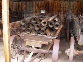
Next we have something I found very interesting. It is a wagon full of logs that had been bored out by hand and then laid in Fairplay to be their water line from 1882 until 1960! I just am amazed at the amount of labor this represented and how their ingenuity won the day!


Each log is cut with a larger section in the inside of the one end and the other end is cut down on the outer side so that each log was able to nestle into the next long and make a leakproof connection.


This is a partial view of the buildings that are open for inspection to the lucky ones who take a moment out and stop to see. It is more than worth the $5.00 per person ticket!

1 Comments:

Blogger Unknown said...

This attraction with all of the pioneer buildings and relics would be real interesting to go through. You're right, those logs used to transport water for the town are amazing!

10:37 AM  

Post a Comment

<< Home

Wednesday, July 12, 2006

Climax Molybdenum

High above Leadville, CO is the Climax Molybdenum Mine which sits at 11,300 feet at the top of Fremont Pass. This mine has been in operation off and on since World War 1 when it was discovered that molybdenum was useful in hardening the steel used for military equipment. For many years, the mine employed hundreds of people from Leadville, Colorado. When it shut down for several years the residents of Leadville were severely affected. Now, the mine is back in operation on a limited scale and the economy of Leadville is based more on tourism than on mining.

The photos shown here are of the tailings from that mine which are filling in the valley below. The memorial stone is in memory of three towns that once sat in that valley.
It is hard for the photos to give the massive size of these tailing but you can believe me when I say it is huge. 30 years ago when I first saw this operation the tailings were hundreds of feet lower in elevation. I was shocked to see how high it has grown.


The intention is to plant trees and vegetation on the tailings when they finish filling up the valley.

If I remember correctly there are 144 miles of tunnels in this mine which just boggels my mind.

2 Comments:

Blogger Unknown said...

Wow, 144 miles of tunnels. I'd never heard of the stuff they're mining. From the size of the trees in the photo, it does look huge.

3:22 PM  
Blogger Jeri said...

That's pretty interesting. Thanks for sharing the pictures and the info.

9:31 AM  

Post a Comment

<< Home

Twin Lakes, Colorado

During the early to mid 1970's Barbara's Father and Mother came to Colorado to fish on their vacations in the summer. One of thier favorite places to go was Twin Lakes which is south of Leadville and north of Buena Vista, CO. These lakes are Glacial lakes and if I remember correctly are the only ones in Colorado.

On several occasions we came out from Lakewood, CO where we were living and spent a weekend fishing with them. The area has changed in that there are more houses and cabins up in the overlooking hills than there were those 30 plus years ago, but the beauty is still there.

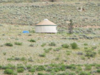
Above is a picture of a Yurt that some adventureous soul placed near the lake. A Yurt is known in many parts of the world as a wonderful tent for the nomadic people.

You can get a sense of the beauty of the setting in the picture of the lake with the mountains in the background. The observant ones will see the cut made by the glacier in the mountain.

We were pleasantly surprised to find that the cabins we stayed at were still there and in use!

1 Comments:

Blogger Jeri said...

I love that shot of the lake and the mountains. Beautiful.

9:33 AM  

Post a Comment

<< Home