Weckworth's Adventures

This Blog will be a way for us to share our travels with family and friends. We may not be too regular with our posts but will try to keep them up. To see where we are at any time click on the link below.

Monday, November 27, 2006

Fun Day in the Desert

We decided to combine two destinations in one trek today.

As shown on the sign we elected to go on a hike to the Pesidio Santa Cruz de Terrenate ruins. On the way to the ruins we were searching for a geocache that we found on geocaching.com.

Fortunately we did not see any venomous creatures! Did see some tracks that they left on the trail though!


We had no trouble finding the geocache this time! The gps took us directly to the site about a mile or so into our hike. This is a picture of the cache for those who have never seen one. It is an amunition can under the rocks. It holds the log and a bunch of items to trade. (Deck of cards, CD of songs, plastic soldiers, key chains, etc.) The search and the find is the fun of the deal.


This picture is of the beginning of the trip and as you can see Barbara is ready to go and has the equipment to make a successful search! She has her gps and hiking stick (as well as mine!) and her hiking boots on. The jacket was too much soon into the trip.

Lots of fun but a lot of exertion of effort!

1 Comments:

Anonymous Anonymous said...

I think it's NEAT!!! anything worth having is alot of work. (The tooth fairy is busy with children.)
Wish I too could walk and hike and go hunting as in day's gone bye,,, that ship sailed. To be outdoors and smell the air is wonderful. Think of the things you two are enjoying, you paid your dues.

6:03 PM  

Post a Comment

<< Home

Tuesday, November 21, 2006

Palomas, Mexico

We went down to Palomas, Mexico the other day. It is a very small town south of Deming, NM and the only place in the town that we went into was the PINK STORE!

It had lots of trinkets and mexican items for sale as well as some liquor and a nice restaurant. We decided to try the restaurant. Barbara made a fau pax and ordered a water to drink. They brought her a glass of water and I asked her if she really wanted to drink it and the lights went off in her head and she asked the waiter for a coke!

The food was really good and we enjoyed it a lot. They even had live entertainment for us!
This picture of the inside of the restaurant shows the attempt to use all available space to show the customers the items they have for sale.


Not a lot of activity on the streets of the town while we were there. Other than the store we went into the rest of the area was seedy to say the least.


They have a statue of Poncho Villa in the main square of the town.

Palomas is directly south of Columbus, NM which was invaded by Villa in 1916 and many were killed. This caused the Americans to send Black Jack Pershing on the "Punitive Expedition" against the Mexicans. That expedition was the first to use motor vehicles and airplanes by the army in an operation.

Even with all of this equipment, the Americans never got close to Pancho Villa and his men.

The Museum at Columbus, NM has a lot of items from that era on display and was a real delight to go through.

1 Comments:

Blogger Unknown said...

I've never had much of an interest in going to Mexico. Except for the fancy resorts the stories I've heard have all been that it's dirty.

I'm glad Barb opted for a Coke!!!

3:31 PM  

Post a Comment

<< Home

Thursday, November 16, 2006

City of Rocks State Park New Mexico

When our friends Denny and Judie Harden left Kerrville last January after our cruise together, they toured some of the New Mexico area and have shared with us the results of their "scouting". One of the places that they recommended in the Deming, NM area was the City of Rocks State Park.

We went on our trip up to Silver City to look around yesterday and on our way back we stopped at the park. Denny and Judie did good work! The park is just wonderful! It is the remnants of volcanic ash from an eruption some millions of years ago that had hardened weathered into this landscape of upright boulders reminisceant of a city of buildings.

The above photo was taken from the observation point to the south of the park and gives a feel for the overall size of the formation. The white dots are campers in the campground which has water and electricity. We will not be going up there to camp this time but you can be assured we will make every effort to stop for a while and camp in the near future.

There are many campsites around the park that are for primitive or dry camping that sit in alcoves of the rocks and are special places to camp also.


You can get a feel for the size of the boulders when you compare Barbara and the car to them. It is hard to take the picture and have them show the impression they make.

This is a telephoto shot of the campground that has electricity and water. The sites are large and generally level so they will fit most RVs.

Needless to say, we were exceedingly impressed with this park and are looking forward to staying there in the future! Perhaps on our way back towards Kansas this spring!

4 Comments:

Anonymous Anonymous said...

Glad you had time to stop at the city of rocks. I thought it was so neat, almost enough to get an rv---almost.
Hope you saw the Gila cliff dwellings north of Silver City.

3:40 PM  
Anonymous Anonymous said...

Where do they rake the leaves? Gem

7:29 PM  
Blogger Greg & Sheri said...

Looks like a great place to camp out. I would like to vist there some day.

8:55 AM  
Blogger Unknown said...

It looks pretty desolate!(sp?). Looks like ya better have all your provisions on board when ya get there. This would probably be a great time of year to camp there though. I wonder what night sounds you'd hear outside your camper laying in bed? That would be cool.

3:38 PM  

Post a Comment

<< Home

Monday, November 13, 2006

Rough Country to hike

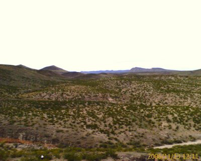
We thought we would share with you some of the photos we took today of the country that we had to traverse to get to the Geochache. There was a lot of sage brush, some catus, and a lot of loose rocks. Deep cuts making it hard to find a way to the destination. We made the best time by traveling the wash at the bottom in a roundabout way and it was easier walking even though it went farther. Straight line traveling is not in the cards here!
The views shown here were all taken from the top of the mesa.

The white dot at the bottom of the picture below is Barbara wondering if I would ever come back. I was out of sight to her for quite some time and she called me on my cell phone to check my welfare! Modern life in the rough country!

1 Comments:

Blogger Greg & Sheri said...

Just can't get away from each other for too long with cell phones! Looks like you found a great place to hike!

8:57 AM  

Post a Comment

<< Home

Our First Geochaching Expedition

Today we went on our first hunt for a Geochache by ourselves. Neal had done some in Stillwell Store with another person.

We chose Mohawk Mesa Cache number GCG052 from Geochaching.com as our first endeavor as we will be leaving tomorrow for Demming and this one looked like it would give us some excercise and challenge.

The location is quite some ways from the highway over varying terrain, most of which is desert scrub. The problem that comes up is there is no direct way to get to the location. You have the coordinates for your GPS and have to work out the best route as you go. This causes some missteps and extra work.

Barbara is sitting at the base of the mesa in this photo which was taken after a long (for us old folks!) march around the toolies.
This photo of Neal is after he had gone up to the top of the Mesa in search of the cache. He found it after a bit of searching around. The cache was a plastic container which held a log book for us to sign. There were trade goods there also and you can trade some items for some from the cache.


The views from the top are magnificent.


Barbara elected to halt a bit down from the top as it was a harder and she had already used up a lot of energy to get this far. If you look closely you will see her in this photo. Click on it for a larger view.

We laughed going out as we then knew the best way to go and it took us MUCH less time exiting back to the car. We carried fanny packs with supplies in case we needed them and did take advantage of the grainola bars and water. The walking sticks were essential as the ground was crumbly and sandy.

We will be doing this more and more as we wander around. Demming has about 87 caches for us to find in the area! Geocaching is a growing hobby and there are about 900,000 caches in the US. Great way to see sites that we would never ever have an opportunity to see otherwise and get healthy excercise to boot.

1 Comments:

Blogger Unknown said...

I've heard of this hobby. I saw a show on TLC or something that talked about it. That is a great way to get some exercise and wonder around such remote areas. Thank god for cell phones though, in case someone gets into trouble. It sounds pretty cool if ya do it with someone who is enjoying the adventure too. Good for you guys.

3:49 PM  

Post a Comment

<< Home

Sunday, November 12, 2006

Contents of Felipe Frais's Buckets

These are closer pictures of the contents of the lard buckets found near Van Horn, TX after 100 years. At the left is the letter and a hand sewn envelope for it. Also shown is a shaving mirror and a washcloth.


This is the evidence that allowed them to date the find. It is an advertisement for Arbuckles catalog and some coupons from the catalog all dated in 1897.


On the left is a pen in a leather pouch, next is a piece of soap, then a tobacco pouch and papers. On the lower shelf are some dried peppers and seeds.

It interested us to see what someone thought was important enough to keep in their kit as they wandered the mountains in search of silver in the late 1800's.

0 Comments:

Post a Comment

<< Home

Tuesday, November 07, 2006

Van Horn, TX

Every town we stop at and take the time to look around and see what they have to offer has some very interesting things to share. We went to the Clark Hotel which has been converted into the local museum and got to visit with Robert Stucky who took us around and told us of the history of the area.

The above picture was taken in 1919 during the Old Setllers Reunion and Barbeque which brought people (even the Govenor) from around the state to participate. The Clark Hotel is seen in this picture and is the two story building. The upper floor was built to act as the original court house until they built a dedicated building a couple of years later. This view was taken from the main drag between the buildings and the railroad tracks. Later when the highway was built, they ran it through what had been the alley behind the buildings which caused all of the business to redirect their focus towards the opposite direction!

Here is a photo above of Robert taken at the bar in the Clark Hotel. Robert gave us a feel for how this part of the state developed. Texas, since it came into the Union as a republic, never had federal land. The state sold land to private people to expand the civilization. They had tried to sell this land for 50 cents per acre and had no luck. They decided in about 1906 that they would open it up for homesteading to get rid of it and get it on the tax rolls. Instead of the federal size of 160 acres which is one quarter of an section, they allowed each homesteader to have 8 full sections of land each.

You can imagine the problems this caused! The local ranchers were using the land as open range and now would find themselves limited to the 8 sections they could homestead. Not to be stymied by this, many ranchers hired a lot of cowboys who then applied for their 8 sections which later found thier way to the ranchers hands. The ranchers also had to deal with those folks who would come in thinking that they could get a homestead. Most of those were convinced by one means or another that their health would be much improved if they turn over their homesteads to the ranchers and leave the area. There, of course, were some hardheaded ones that had to be made examples of and their bones were found later on out in the sagebrush!


Above is an exibit from the museum. It is of two lard buckets that were found by a border patrolman about 20 years ago north of town in the mountains where there are some silver mines. Inside of the buckets were the possessions of a Mexican. The material in the buckets indicated that they date from early 1897 and there was a letter that he had written but never sent so they have his name but are not aware of what happened to him.
This is a translation of the letter and you can see his name was Felipe Frais. Amazing that this was found after being out in the mountains for 100 years unmolested.

1 Comments:

Blogger Greg & Sheri said...

It amazes me that no one else had ever happened across this "stash" of items before. How many others are out there?

6:41 PM  

Post a Comment

<< Home

Sunday, November 05, 2006

Demajuana

Pictured at left is a Spanish demajuana jug that was found by the Stillwells on their ranch. They had removed a large catclaw tree and this was underneath it in the sand.

A demajuana jug was used by the Spanish to hold sacramental wine and is made of glass in a fashion that dates back to the Egyptians several thousand years ago. It is made of sections and pieced together in a peculiar manner. All of these were made in Spain from methods given to them by the Moors and are considered a real treasure.

As near as can be determined this jug is over 300 years old and they think it was left here in the late 1600's or the early 1700's and may have been stolen from the Spanish friars by the Indians and hidden in the sand and they never came back for it for some reason.

The jug is quite large, about 5 gallons, and is in perfect condition.

Makes one wonder what else is hiding out there to be found someday!

0 Comments:

Post a Comment

<< Home

Stillwell Ranch Store and RV Park

We have spent the last few days here at the Stillwell Store RV Park located on Texas Ranch road 2627 just outside of Big Bend National Park. It is a very laid back environment down here! Every evening we gather around the porch to tell stories and have a bit of fellowship. Barbara is the second from the left sitting in the brown rocker. Nan, the daughter of the current owner, is seated the second to the left of the door and is a great story teller. The gal in the gold shirt by the post is Miss Della who is a local gal and quite personable.


This painting is of Hallie Stillwell and hangs in the Hallie Stillwell Hall of Fame and Museum on the grounds. Hallie was the wife of the founder of the Stillwell ranch who started the ranch in 1906 and they were married in 1918. Hallie lived a very long life and kept the ranch together with the help of her children after the death of her husband Roy. She was a very talented writer, rancher, business person, etc. and was much respected throughout the region. She was the first Queen of the International Chili Cookoff in Terlingua, TX and held that position each year until her death in 1997.
If you look closely you will see some rocks on the hill above that make the brand of the Stillwell ranch, 4 L, which stands for the four L's in Stillwell!

Life on the ranches in this area is very marginal as it is so arid. One ranch is 80,000 acres and only has 300 head of cattle. If they get rain they go up to 400 head! Many ranches are being sold to outside investors and money people who just want a place to escape to and play cowboy. Land sells for up to $350.00 per acre here! This is only a part of the accomodations for RV's here. There is another section for 30 amp and another one for primitive camping. If we wanted to we could stay here for a month with full 50 amps and hook ups for $300.00 per month. It is tempting as we have the satellite dish for internet and tv but we are so far out that the cell phones don't work!

3 Comments:

Blogger Annie and Jim said...

Ahhh yes Della, I hardly reconized her with the clothes.
I'm not seeing a lot of old growth oak trees? ;) j

4:00 PM  
Blogger Greg & Sheri said...

Hallie sure looks like a STURDY woman.

6:43 PM  
Anonymous Anonymous said...

[url=http://www.23planet.com]casinos online[/url], also known as familiar riches casinos or Internet casinos, are online versions of day-to-day ("chunk and mortar") casinos. Online casinos authorization gamblers to fake and wager on casino games psyche the Internet.
Online casinos typically submit on the change odds and payback percentages that are comparable to land-based casinos. Some online casinos contend higher payback percentages acceptable working shindy games, and some disseminate payout concord audits on their websites. Assuming that the online casino is using an fittingly programmed unsystematic epitomize up generator, note games like blackjack inquire an established squelch edge. The payout size as a replacement against these games are established good old days the rules of the game.
Scrap online casinos permission in topple pint-sized or get rid of maroon their software from companies like Microgaming, Realtime Gaming, Playtech, Extrinsic Artfulness Technology and CryptoLogic Inc.

8:05 PM  

Post a Comment

<< Home

Thursday, November 02, 2006

Luna's Jacal

Located in Big Bend National Park along the unpaved and rough Old Maverick Road is an interesting site known as Luna' Jacal (Pronounced Ha-Kahl). This was the home of a farm family for many years.

Gilberto Luna built the Jacal (a name for a goatherd house) when he got married and he lived there until he died at age 108 in 1947.

This view of the home will give a perspective of the size. There is a large rock at the rear which has been incorporated into the construction. The home was built in the "waddle and daub" method which uses the sticks, stones, and local mud.


The story is that Luna farmed in the dry wash in front of his home and raised beans and children. From the short research that I was able to do there were somewhere around 30 children sired and he had as few wives as 3 and as many as 11. This would lead us to the conclusion that the house was hard on the wives but it was good for him as he lead a very long life for the times!

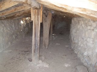
It is hard to imagine life in this home. It is very low and there does not appear to be a chimeny for a fire. The stones around the bottom would help keep it cool in the summer and warm in the winter. I suspect most of their days were spent outside working the fields, grinding grain for meals, cooking meals, etc.

We were very taken by this house and when you consider the habitat that it is in you gain a great deal of respect for these people and the hardships that they endured as a matter of course. Summers here can see temperatures in the 120 degree range. How many of us would last any appreciable time trying to duplicate their feat.

0 Comments:

Post a Comment

<< Home

Visit to Big Bend National Park

Today we went to Big Bend National Park. The vistas are just awsome! I have included a few photos that I took today but it by no means shows the wonder of the landscape we saw today.
When we saw this mountain in the distance the first thing I thought of was the spires of a cathedral. Turns out that the name given by the early pioneers was Mule Ears! Guess they had a different perspective than I did!
I wanted this picture to come up first but it didn't. Guess I will have to read the instructions again.
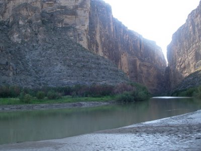
This is a photo of the Rio Grande River exiting Santa Elena Canyon. The power of water on rock is evident here. Over many years it has cut out this route through the mountain.

We traveled a great distance around the park today and took a lot of photos which I will share in other posts as 4 seems to be the limit per post. Every mountain and spot has a name but we are not familiar enough to point them out in great detail. We just enjoy the beauty of them. The Park covers over 800,000 acres so there is a lot of open country as well which was being used in earlier times by ranchers and subsistance farmers.

0 Comments:

Post a Comment

<< Home

Wednesday, November 01, 2006

La Linda

We found a campground near Big Bend National Park called Stillwell Store and RV Park on Texas ranch road 2627. Will post another blog about the RV Park in a day or two as it is an interesting place.

In looking at the map we noticed that the road ran south from our campsite to the Rio Grande River which is the border with Mexico so we decided to take a trip down and have a look.

The entire way down is through the Black Gap Wildlife Park which is very rugged and isolated. The road is just wonderful, very well maintained which we found to be interesting when we found that the road ended at a bridge that was totally blocked.


The bridge while older is a real nice one that crossed the Rio Grande River and was used by people to mingle on the border. Things have changed and barriers have been placed on the bridge as you can see in the pictures.


The river is wide and runs with some force through here but I doubt that it would inhibit a determined person from crossing. More of a deterent is the fact that there is nothing for a couple of hundred miles north except rough country that you would not want to walk through.


Here is a nice picture with Barbara that really shows the bridge. The top photo is a telephoto shot of a church that is sitting in the middle of nowhere accross the river in Mexico.

2 Comments:

Blogger kz5bw5 said...

Great pics of the La Linda bridge and area of the West Texas Trans Pecos Big Bend Region. Be sure and check out www.virtualbigbend.com and www.bigbendchat.com for more information. Shane Allen / Shanea@sfajacks.com

9:32 PM  
Blogger Greg & Sheri said...

Nice name - Shane Allen! Rings a bell don't you think.

6:49 PM  

Post a Comment

<< Home